
MOUNT BATUR
is an active volcano located at the center of two concentric calderas north west of Mount Agung Bali
The south east side of the larger 10×13 km caldera contains a caldera lake. The inner 7.5-kilometer-wide caldera, which was formed during emplacement of the Bali . has been dated at about 23,670 and 28,500 years ago
The southeast wall of the inner caldera lies beneath Lake Batur; Batur cone has been constructed within the inner caldera to a height above the outer caldera rim. The Batur stravovolcano has produced vents over much of the inner caldera, but a NE-SW fissure system has localized the Batur I, II, and III craters along the summit ridge. Historical eruptions have been characterized by mild-to-moderate explosive activity sometimes accompanied by lava emission. balsatic lava flows from both summit and flank vents have reached the caldera floor and the shores of Lake Batur in historical time.

The caldera contains an active, 700-metre-tall stratovolcano rising above the surface of Lake Batur. The first historically documented eruption of Batur was in 1804, and it has been frequently active since then. The substantial lava field from the 1968 eruption is visible today when viewed from Kintamani a town that stradles the southwest ridge of the greater caldera.
The caldera is populated and includes the two main villages of Kedisan and Toya Bungkah. The locals largely rely on agriculture for income but tourism has become increasingly popular due to the relatively straightforward trek to the summit of the central crater


GALLERY PHOTOS BY : KOMANG FERRY

Historical
eruptions have been characterized by mild-to-moderate explosive
activity sometimes accompanied by lava emission. Basaltic lava flows
from both summit and flank vents have reached the caldera floor and the
shores of Lake Batur in historical time.


LAKE BATUR
is the
widest lake in this island. It lies down in the feet of
Mount Batur and Mount Abang.
The surrounding of the lake is a favorite place for picks
you self up.
At lake Batur you can see the scenic view and feel cool atmosphere.
At lake Batur you can see the scenic view and feel cool atmosphere.
Bangli's mountainous region centers around the spectacular volcanic crater (or caldera) of Batur. Mount Batur itself is actually just a small volcano, but its setting is in the heart of a huge crater. Adjacent to the volcano is the large crescent-shaped Batur Lake, all surrounded by the high walls of the crater rim.
As the road rises steadily from
Bangli or Tampaksiring, nothing in the surrounding grey
landscape of bushes and garden plots suggest the presence
of a volcano. But over, one more small ridge a dizzying
view awaits the eyes, encompassing the crater and beyond.
From Penelokan, the main road runs right round the rim
towards Kintamani, the panorama shifting as circling around
the crater.
The sheer size of the crater conjures
up images of the massive eruption of the original Mount
Batur that occurred tens of thousands years ago. The volcano
is still active today as Balinese still remember the great
eruption of 1917. It claimed thousands of lives and destroyed
hundreds of temples.


Other eruptions have taken place since forcing the local population to be relocated, along with several of their temples, including the main Bali Temple, Pura Ulun Danu. Initially inside the huge crater, this temple has been relocated to the top of the ridge overlooking it. Here it now offers an impressive view of Mount Batur.
Located less than an hour from
north Bangli. Danau Batur is Bali's largest lake and cribbed
with the calderas of an active volcano named Gunung Batur.
RESTO APUNG ( FLOATING RESTAURANT )


KEDISAN VILLAGE
is a small rural village nestled at the foot of the mount Batur on the island of Bali, at the edge of Lake Batur the largest lake in on the island. The village sits amidst the
panoramic setting of the crescent shaped lake and the majestic volcano
filling the skyline above. It is one of 15 villages in the Kintamani Region, about 2 hours north from Denpasar capital city of Bali.
Located between Lake Batur’s shore and
the magnificent Mount Batur, Kedisan’s soil is well irrigated by the
river and incredibly fertile due to the volcanic ash. That, combined
with the cool mountainous climate makes it the perfect crop-raising
terrain. It’s no wonder, therefore, that this region is inhabited
largely by those that make a living by farming. Kedisan’s colorful
patchwork of agricultural produce includes onions, cabbages, peppers,
tomatoes and much more. Some residents of Kedisan also work as
fisherman, as Lake Batur is home to quite the abundance of fish.

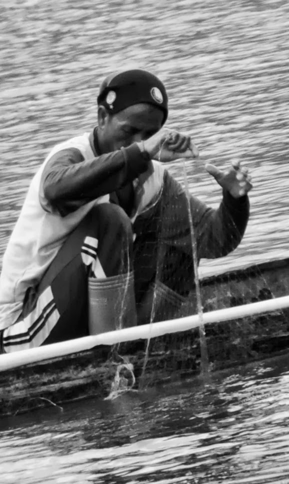
To Catch the fish
The Kintamani region has been well known
since the 9th century, as is proven by various royal edicts engraved on
copper plates found throughout Kedisan and the other villages around
Lake Batur, such as Trunyan, Songan and Buahan

In every single path of my pedal there is a hope


silent mode on to catch the fresh water fish


The body soak into the water


PHOTOS AND MOMENT BY : KOMANG FERRY


THE TRAVELERS GALLERY PHOTOS


IGA TOUR TEAM OUT OF THE BOX
THE PHOTOS GALLERY


CREATING TRULY MEMORABLE EXPERIENCE
Come and Join With Us !!!!! See You Later

No comments:
Post a Comment